
Abstract
The aim of this study was to identify suitable locations for solar kilns in Vientiane, the capital of Laos, based on geographical and climatic conditions and restricted areas. The criteria of the parameters, which were incorporated with Fuzzy membership functions, were used to create layers in the ArcGIS environment to draw maps of suitability. Climatic parameters, based on the Fuzzy method, were used to investigate the period of productive performance for solar kilns. The results showed a range of possible locations. The most suitable locations were in flat areas near roads. They were far from protected areas, rivers, and flood prone areas. The most productive performance period for operating solar kilns was from November until May.
Download PDF
Full Article
Applying a GIS-based Fuzzy Method to Identify Suitable Locations for Solar Kilns
Khamtan Phonetip,a,b,* Barbara Ozarska,a Graham Ian Brodie,a Benoit Belleville,a and Latsamy Boupha b
The aim of this study was to identify suitable locations for solar kilns in Vientiane, the capital of Laos, based on geographical and climatic conditions and restricted areas. The criteria of the parameters, which were incorporated with Fuzzy membership functions, were used to create layers in the ArcGIS environment to draw maps of suitability. Climatic parameters, based on the Fuzzy method, were used to investigate the period of productive performance for solar kilns. The results showed a range of possible locations. The most suitable locations were in flat areas near roads. They were far from protected areas, rivers, and flood prone areas. The most productive performance period for operating solar kilns was from November until May.
Keywords: Fuzzy membership function; GIS; Solar kiln; Wood drying
Contact information: a: School of Ecosystem and Forest Sciences, Faculty of Science, The University of Melbourne, Burnley Campus, 500 Yarra Boulevard, Richmond, Victoria, 3121, Australia; b: Department of Forest Economics and Wood Technology, Faculty of Forestry Science, The National University of Laos, DongDok Campus, Xaythany district, Vientiane, Lao P.D.R.;
* Corresponding author: khamtanfof@gmail.com
INTRODUCTION
A Geographic Information System (GIS) is a powerful tool to analyze spatial data. It has been widely used by many researchers in suitability studies for site selection, often in combination with other analytical tools, such as the Fuzzy Theory, which was introduced by Zadeh (1965). The Fuzzy set is an object class with a continuum of membership grades. A set of the membership function is assigned to each object, with a membership grade ranging between zero and one. This method has been incorporated with GIS tools to select suitable sites for solar and wind farms (Effat 2013; Uyan 2013; Asakereh et al. 2014; Yunna and Geng 2014; Aly et al. 2017). However, applying such methods to identify suitable sites for solar kilns for wood processing industries has not yet been defined.
Solar drying has been considered as an environmentally friendly process because it reduces carbon dioxide emissions by using solar radiation to generate heat. In contrast, steam kilns usually use firewood (Redman 2016), and such kilns emit up to 60% of the wood mass as carbon dioxide (Wibe 2012).
Solar kilns were introduced as a suitable drying method in tropical latitudes, where the solar radiation and temperature are high (Simpson and Tschernitz 1984). However, a detailed analysis of several parameters, such as geographical and climatic conditions and restricted areas, are still required to select the most suitable sites for solar kilns because the geographical latitudes and climatic patterns of each location are slightly different and can affect drying time. For example, Hasan and Langrish (2014) predicted that solar drying of Tasmanian eucalyptus (Eucalyptus obliqua) boards from a moisture content (MC) of 30% down to 10% was faster in Brisbane (Australia) than in Melbourne (Australia) by 10 d. This was because the solar radiation in Brisbane was higher than in Melbourne during the spring. Thus, the temperature inside the solar kiln in Brisbane reached 55 °C, which was 10 °C higher than in the one in Melbourne. However, geographical conditions have not yet been considered as potential parameters that may affect drying conditions.
Defining and selecting parameters for suitable locations for solar kilns is necessary to ensure efficient performances. A standard drying process usually uses heat, relative humidity (RH), and air velocity to dry timber. However, as stated above, solar kiln drying is usually affected by geographic and climatic conditions, i.e. the temperature inside the kiln is affected by the ambient temperature and solar radiation (Phonetip et al. 2017a). The level of heat at the surface of materials decreases when the wind speed increases (Reddy et al. 2016). Areas with low humidity offer a productivity performance for solar kilns (Ong 1997). For example, according to Phonetip et al. (2017b), decreasing the RH level to 40% can dry boards faster than when the conditions are maintained at 60% RH. Taking advantage of a low ambient RH could result in several benefits, such as lowering the consumption of water and energy. Therefore, a RH less than or equal to 40% should be regarded as the most suitable RH level for solar kilns.
Vientiane was selected as the study area. It is located within the tropical region of Laos. Vientiane was chosen because there are many wood processing factories in this location; more than in any other region of Laos. Seventy-two companies are registered as members of the Lao Furniture Association (Lao Furniture Association 2017). There is an increasing interest in using solar kilns among timber companies in Laos (Phonetip 2014). According to Laos National standards, wood processing factories are required to have kiln dryers (MoIC 2009), and all timber should be processed before the products are exported (MoIC 2016). Using solar kilns could contribute to reducing the operational costs of wood processing.
A ‘smart’ solar kiln, which has been used for drying timber boards by Phonetip et al. (2017a), allows for control of the drying conditions. For example, the temperature and RH level (up to 90%) can be controlled. The available heat depends on the ambient temperature level and can reach 50 °C in Melbourne.
Because solar kilns can dry timber faster than air drying (Armstrong 1914), using smart solar kilns in combination with existing conventional kilns can shorten drying times, which means lower operational costs. Identifying suitable locations to maximize drying performances is an important factor in solar kiln installation.
The objectives of this study were to identify suitable locations for solar kiln installation and to recommend drying periods during different seasons of the year that would offer optimal drying performances.
EXPERIMENTAL
Materials
Vientiane, the capital city of Laos, is located in the central part of the country at 18° 4′ 52.72″ N and 102° 35′ 43.66″ E (Fig. 1). It has a total land area of 3292 km2. Existing data and digital maps from various organizations were utilized for the evaluation process. The data set included the aspect and slope percentage, which were generated from a Digital Elevation Model (DEM), roads, rivers, and conservation areas consisting of national biodiversity conservation areas (NBCAs) and forest protected areas. This data was derived from the Faculty of Forestry Science (2017). The temperature data was sourced from Climate Engine (2017). Precipitation, daylight hours, and cloud cover were sourced from the Surface Meteorology and Solar Energy (NASA 2017). The solar radiation data was obtained from World Bank Group (2016). Flooding areas in ‘shapefile’ form were provided by the Mekong River Commission. The map layer of flooding areas was combined with rivers. The wind speed data was sourced from Fick and Hijmans (2017). The RH data was downloaded from University of East Anglia (2017). All of the original maps had global and regional scales, which were processed by clipping and masking for the Vientiane boundary using ArcGIS 10.4.1 (Version: 10.4.1.5686; Esri, Redlands, CA, USA).
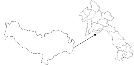
Fig. 1. Study site (Vientiane, the capital city of Laos)
Methods
Classification criteria for identifying suitable locations
Suitable locations for solar kilns can be determined using three parameters based on the geographical, climatic, and restricted area data sets. These parameters should offer benefits for solar kilns (greenhouse type) used for drying timber (Phonetip et al. 2017a). The geographical conditions included the slope percentage to indicate the optimal slope level. Another condition was the slope aspect, which indicates areas with better exposure to high solar radiation. The climatic conditions included temperature, solar radiation, RH, wind speed, cloud cover, daylight, precipitation, and solar intensity across the annual seasons (i.e. solar azimuth and solar elevation). The restricted area data set included NBCAs, forest protected areas, and distances from high flood risk zones. Additionally, suitable locations should be positioned near roads for convenient access.
Fuzzy membership functions were utilized to create all the layers of the suitability map. Each layer represented a map of parameters that contained values between zero and one.
The Fuzzy results for each layer, based on input raster maps, were calculated through the Map Algebra expression tool in the ArcGIS software. The assigned criteria were for the benefit of a specific type of solar kiln (Solarkilns Pty Ltd, Kilsyth, Australia). For instance, Phonetip et al. (2017a) found that a solar radiation value of 0.2 kWh/m2/d can result in a temperature between 30 °C and 40 °C inside this type of solar kiln.
Therefore, Fuzzy membership functions for solar radiation were expressed as Eq. 1. This was based on values between 0.2 kWh/m2/d and 0.4 kWh/m2/d being regarded as moderate. If the value was greater than 0.4 kWh/m2/d, it was assigned the most suitable level (one); otherwise, it was the least suitable (zero). The authors also suggested that an ambient temperature of 25 °C could result in kiln temperatures ranging from 25 °C to 45 °C. This was expressed in Eq. 2, which was used to calculate the Fuzzy value of the temperature layer,
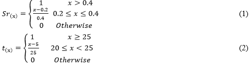
where Sr(x) and t(x) are the Fuzzy membership values for the solar radiation (kWh/m2/d) and temperature (°C), respectively.
Because the effects of the wind speed on the heat loss for this specific solar kiln were not available, the value was obtained from Reddy et al. (2016). The study found that when the wind speed over an object increased, the heat loss in that object increased. Thus, to store heat in the solar kiln for longer periods, the wind speed outside the solar kiln needs to be lower. Equation 3 was used to map the Fuzzy value of the wind speed,

where Ws(x) is the Fuzzy membership value for the wind speed (m/s).
The percentage of cloud cover affects the amount of solar radiation received, with solar radiation increasing when the sky is clear (Tzoumanikas et al. 2016). Long daylight hours usually provide the potential for more solar radiation. The solar azimuth and solar elevation obtained from the Sun path chart program from University of Oregon (2017) indicated a high solar exposure. Therefore, the suitability levels, as in Eqs. 4, 5, 6, and 7, were used for the percentage of cloud cover, daylight hours, degree of solar azimuth, and solar elevation, respectively.
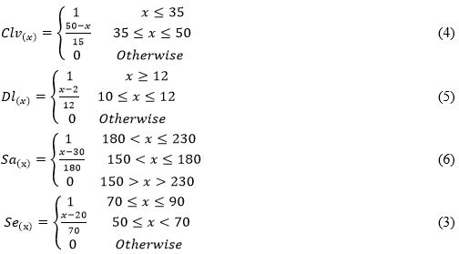
where Cv(x), Dl(x), Sa(x), and Se(x) are the Fuzzy membership values for the cloud cover (%), daylight (h), solar azimuth (°), and solar elevation (°), respectively.
During the timber drying process, a lower RH and higher temperature are used to reduce the wood MC. Phonetip et al. (2017b) found that drying timber using a solar kiln at 60% RH from a green condition to 12% was 50% slower than at 40% RH when the temperature oscillated from 15 °C to 45 °C. Thus, it appeared that a lower RH is more suitable than a high RH. Therefore, the RH was modelled as Eq. 8. Various studies revealed that higher amounts of precipitation reduce the downward shortwave radiation that reaches the surface of the earth, and thus leads to surface cooling (Zhao and Khalil 1993; Stuart and Isaac 1994; Trenberth and Shea 2005; Wu et al. 2013). However, how the level of precipitation affects the diurnal temperature is not currently known; therefore, the range of precipitation data in the study region was utilized and categorized into the three classes, which are expressed in Eq. 9.
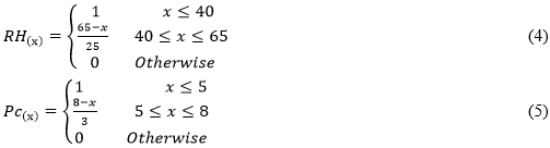
where RH(x) and Pc(x) are the Fuzzy membership values for the RH (%) and precipitation (mm/d), respectively.
Flat areas that provided easy and low-cost access are suitable locations for solar kilns. The most suitable locations are where the slope is less than 10% and moderate suitability is where the slope is not greater than 15%. The slope percentage classification (Eq. 10) was derived from Asakereh et al. (2014). South-, southeast-, and southwest-facing aspect locations are the most suitable as solar radiation is the highest in these directions. In this case, the solar azimuth (Fig. 3) derived from the Sun path chart program (University of Oregon 2017) was considered for modelling the most suitable level in the Fuzzy calculation, as shown in Eq. 11.
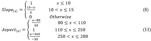
where Slope(x) and Aspect(x) are the Fuzzy membership values for the slope (%) and aspect (°), respectively.
Five hundred meters is allowed as a buffer zone for NBCAs and forest protected areas. This value was based on the Forestry Law of Laos (NAL 2007). The Fuzzy membership values in Eq. 12 were assigned based on the NBCA restrictions. Another restriction was that solar kilns should not be installed within 500 m of rivers because flooding may occur. The Fuzzy membership values in Eq. 13 were assigned based on locations near rivers. Locations within 500 m of flood-prone areas were restricted, which was assigned in Eq. 14. Suitable locations should not be further than 1 km from access roads, as was assigned in Eq. 15,
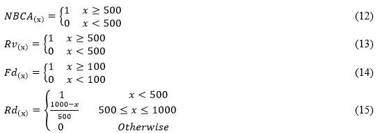
where NBCA(x), Rv(x), Fd(x), and Rd(x) are the Fuzzy membership values for the NCBAs (m), rivers (m), flood areas (m), and roads (m), respectively.
All of the layers were processed based on the assigned criteria and overlay using the Fuzzy membership functions and Fuzzy Overlay Tools in ArcGIS 10.4.1, followed by the modeling shown in Fig. 1A in the Appendix section to visualize the suitability map.
Productive performance of the solar kilns
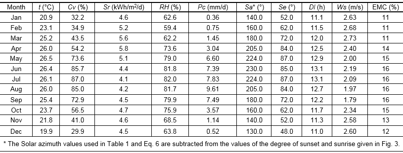
After the suitable locations were defined, the climatic conditions were the main criteria that were used to analyze the productive performance period for solar kilns. The parameters included the average temperature (t), RH, precipitation (Pc), solar radiation (Sr), daylight (Dl), solar azimuth (Sa), solar elevation (Se), wind speed (Ws), and cloud cover (Cv). The monthly mean values for each parameter, which are presented in Table 1, were derived from POWER Surface Meteorology and Solar Energy (NASA 2017). The final MC of the timber exposed to atmospheric conditions was determined using the equilibrium moisture content (EMC) as a function of the dry bulb temperature, wet bulb depression, and RH (Oliver 1997). The Fuzzy method was utilized and manipulated using a standard spreadsheet (Excel 2016, Microsoft, Redmond, WA, USA). The monthly average for the Fuzzy values were estimated using Eq. 16,
![]() (7)
(7)
Where is the average Fuzzy value for a specific month, Fi is the Fuzzy value of the input climatic parameters (temperature, cloud cover, solar radiation, RH, precipitation, solar azimuth, solar elevation, daylight, and wind speed) for each month (these values were derived from Eqs. 1 through 9), and N is the number of parameters used.
Table 1. Monthly Climatic Conditions in Vientiane
RESULTS AND DISCUSSION
The outputs of the Fuzzy values are illustrated in Fig. 2. The darker areas represent the most suitable locations (Fuzzy value close to one) where solar kilns should be installed, while the lighter areas indicate unsuitable locations (Fuzzy value close to zero).
The slope aspect (Fig. 2a) was determined through the most suitable aspect from the southeast to southwest according to the solar azimuth input value (Eq. 6). The lowest Fuzzy value was 0.9. This implied that most of the locations within Vientiane received optimal solar exposure. Most of the slopes (Fig. 2b) that were steeper than 15% were found in mountainous areas, which are protected areas; the remaining areas should be suitable, as the slope was less than 15% and more than 500 m from conservation areas, as stipulated by NAL (2007). The restricted areas (Fig. 2c) consisted of NBCAs, forest protected areas, flooding zones, and rivers, which were clipped into a layer of restriction.
Vientiane had a high solar radiation value (Fig. 2d), i.e. a Fuzzy value of one was found for the entire area because the average annual solar radiation was higher than 4 kWh/m2/d (World Bank Group 2016), which was higher than the required criteria (> 0.2 kWh/m2/d) that was suggested by Phonetip et al. (2017a). The high temperature level (Fig. 2e) was also adequate for heating solar kilns, as the minimum Fuzzy value was 0.9. The Fuzzy values for the temperature and solar radiation confirmed the earlier suggestion made by Simpson and Tschernitz (1984) that tropical latitudes were the most suitable locations to implement solar kilns because the solar radiation and temperature levels are high.
The maximum wind speed (Fig. 2f) in Vientiane was 1.9 m/s according to the data from Fick and Hijmans (2017). The minimum Fuzzy value was 0.6, which was beneficial because the wind speed has to be low based on the criteria used in the Fuzzy calculation by Reddy et al. (2016). However, it was undeniable that one area may be different from another, in terms of the effect of wind speed. For example, the wind speed increases in desert areas, which may increase heat because of the influence of heatwaves. This implied that the suggestion made by Reddy et al. (2016) might not be suitable for all geographical conditions. Hence, the Fuzzy membership expression in the map algebra may be revised accordingly in future works.
The road map (Fig. 2g) was created with the aim of locating road network accessibility. Suitable locations should not have been more than 1000 m away from roads. This was clearly mapped using Eq. 15.
The available scale of the RH map (Fig. 2h) covering the study site had a very low resolution. However, the range of RH values was higher than the specified requirements. For instance, the average annual RH ranged from 74% to 80%, while the required criteria used in the Fuzzy membership function, based on suggestions made by Phonetip et al. (2017b), had a maximum RH of 65%. When this layer was added using Eq. 8 with the Fuzzy membership tool, the Fuzzy value was unable to be calculated. For example, the continuum grade from -3.40282e+038 to 3.40282e+038 is the default range in ArcGIS software. Because the Fuzzy value lay outside this range, it gave a NULL result.
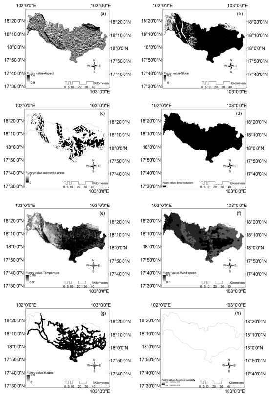
Fig. 2. Fuzzy values of the aspect (a), slope (b), restricted areas (c), solar radiation (d), temperature (e), wind speed (f), roads (g), and relative humidity (h)
In this case, the RH layer could not be used for further map processing because the Fuzzy overlay function multiplied all of the values of the combined layers. Thus, the RH data was not suitable. This suggested that using the RH or any other layers that contained NULL value on a small scale, like the geographical size of Vientiane, was not possible. However, it might be useful on a larger scale, where the RH has a range of values lower than 65% across the study site, as required by the Fuzzy membership function noted in Eq. 8.
The results of overlaying all of the layers using the Fuzzy overlay tool are illustrated on the map in Fig. 3. The map can be used as a guide for the selection of locations for installing solar kilns within Vientiane. Most of the identified suitable locations were adjacent to roads and far from NBCAs, forest protected areas, flood prone areas, and rivers. It should be noted that, for the reasons outlined above, the RH layer was not included in this suitability map.
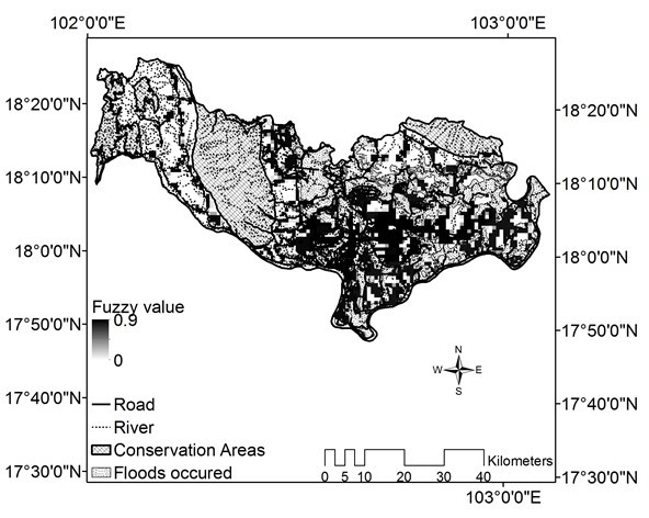
Fig. 3. Suitability map for solar kilns in Vientiane, Laos
This method improved the depth of understanding of the effect of related geographical parameters. The locations that could offer faster drying were those areas that were exposed to higher amounts of solar radiation and temperatures. Hence, the slope aspect was one of the parameters that determined the areas that met the requirement of higher radiation. For instance, the suitable aspect degree was between 110° and 250° for Vientiane (University of Oregon 2017). From these results, a method for identifying suitable locations for solar kilns could be incorporated with the numerical simulation tool introduced by Hasan and Langrish (2014) for further validation and site comparisons.
To maximize the optimal performance for the simulation of solar drying using a conventional kiln, which was introduced by Phonetip et al. (2017b), utilizing climatic conditions should account for the slope aspect where there is a high solar radiation exposure.
The monthly productive performance for solar kiln use in Vientiane is shown in Fig. 6. The analysis of the data used Fuzzy values for the temperature, RH, precipitation, solar radiation, daylight, solar azimuth, solar elevation, wind speed, and cloud cover. The results showed that over the period of December to May, the Fuzzy values ranged from 0.69 to 0.80, and the maximum value was reached in March. This period corresponded to the dry season in Vientiane. However, considering the average Fuzzy value in each month, the minimum value was 0.63, which was titled as a high membership of Fuzzy set “one”. Thus, an adequate productive performance level of solar kilns was possible from June to October. Additionally, EMC values considered as the final MC in boards could be reached (Oliver 1997) are also given in Fig. 4. Thus, lower EMC values indicate faster drying rates. The EMC values were calculated based on the monthly temperature and RH in Vientiane (Table 1). It can be seen that the mean maximum EMC was 16% (May to October). This implied that the drying rate of timber during the rainy season is slower than in the dry season because the EMC was 5% lower (i.e. EMC = 11%). Based on the results, the most highly recommended period for drying is between November and May.
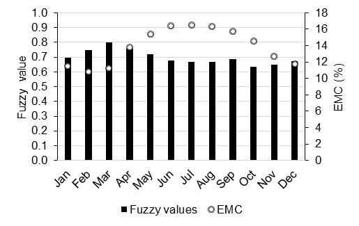
Fig. 4. Monthly productive performances of solar kilns in Vientiane, Laos
CONCLUSIONS
- This study described a method that used the combined tools of GIS and Fuzzy theory to identify the most suitable locations for solar kilns in Vientiane, based on variables of geographical and climatic conditions and restricted areas. The results showed that the ideal locations were those with a flat topography (e. slope of less than 15%), high temperature, and high solar radiation levels. More precisely, the best locations ranged from southeast- to southwest-facing aspects with good road access that were far from flood risk zones and rivers and away from restricted access areas. This method can be applied to different geographical regions and local seasons.
- A few suggestions or considerations were cropped up when applying this method. First, the wind speed parameter used in this analysis will vary across different regions. Therefore, exploring the effect of the wind speed on the heat loss of the materials is recommended. Second, the Fuzzy membership values assigned based on the required values should not be higher or lower than the available levels. Otherwise, the results could turn to NULL value, which occurred for the RH, as has been discussed in this paper.
- The most productive period for performance of solar kilns in Vientiane based on the Fuzzy values was determined to be November to May.
- As the dimension data of 3D buildings in Vientiane was not available to be used in calculating the effects of shade from buildings, this parameter could not be assessed. It is recommended that site visits be undertaken to ensure that the identified suitable locations are not impeded by tall buildings or other nearby infrastructures before installing solar kilns.
REFERENCES CITED
Aly, A., Jensen, S. S., and Pedersen, A. B. (2017). “Solar power potential of Tanzania: Identifying CSP and PV hot spots through a GIS multicriteria decision making analysis,” Renew. Energ. 113, 159-175. DOI: 10.1016/j.renene.2017.05.077
Armstrong, J. (1914). Wood Industry Factsheet (DR1), West Virginia University, Morgantown, WV.
Asakereh, A., Omid, M., Alimardani, R., and Sarmadian, F. (2014). “Developing a GIS-based Fuzzy AHP model for selecting solar energy sites in Shodirwan region in Iran,” International Journal of Advanced Science and Technology 68, 37-48. DOI: 10.14257/ijast.2014.68.04
Climate Engine (2017). “Maximum and minimum temperature for the location of 102.5634E, 17.9864N (Vientiane, Laos),” (http://clim-engine.appspot.com/#), Accessed 16 September 2017.
Effat, H. A. (2013). “Selection of potential sites for solar energy farms in Ismailia Governorate, Egypt using SRTM and multicriteria analysis,” International Journal of Advanced Remote Sensing and GIS 2(1), 205-220.
Faculty of Forestry Sciences (2017). Road, Rivers, Vientiane Boundary and National Biodiversity Conservation Areas, The National University of Laos, Vientiane Capital, Laos.
Fick, S. E., and Hijmans, R. J. (2017). “Worldclim 2: New 1-km spatial resolution climate surfaces for global land areas,” International Journal of Climatology, (http://worldclim.org/version2), Accessed 28 October 2017.
Hasan, M., and Langrish, T. (2014). “Numerical simulation of a solar kiln design for drying timber with different geographical and climatic conditions in Australia,” Dry. Technol. 32(13), 1632-1639. DOI: 10.1080/07373937.2014.915556
Lao Furniture Association (2017). “Members directory,” (http://www.lfalaos.com/page/membersdirectory), Accessed 30 August 2017.
Ministry of Industry and Commerce (2009). “Agreement on the standardization of wood processing,” MoIC, Vientiane, Laos.
Ministry of Industry and Commerce (2016). “Approvement for export products of wood and ban lists,” MoIC, Vientiane, Laos.
Mekong River Commision (MRC) (2003). Estimated Extent of a Major Flood Event, MRC, Vientiane, Laos.
The National Assembly of The Lao People’s Democratic Republic 06/2007 (2007). “Law No. 06/2007 of December 2007 for Forestry,” The National Assembly of The Lao People’s Democratic Republic, Vientiane, Laos.
NASA (2017). “POWER surface meteorology and solar energy (SSE),” ESRI, (https://asdc-arcgis.larc.nasa.gov/sse/), Accessed 20 September 2017.
Oliver, A. (1997). Australian Timber Seasoning Manual, Australian Furnishing Research and Development Institute Limited, Launceston, Tasmania.
Ong, K. S. (1997). “Comparison between drying of timber in a solar dryer and in an electrically-heated kiln,” Dry. Technol. 15(3-4), 1231-1237. DOI: 10.1080/07373939708917289
Phonetip, K., Brodie, G., Ozarska, B., and Belleville, B. (2017a). “Drying Eucalyptus delegatensis timber by solar kiln using an intermittent drying schedule of conventional laboratory kiln,” submitted to Dry. Technol.
Phonetip, K., Ozarska, B., Belleville, B., and Brodie, G. (2017b). “Using a conventional laboratory kiln as a simulation of solar cyclic drying,” in: IUFRO Division 5 Conference/ SWST 60th International Convention Forest Sector Innovations for a Greener Future, Vancouver, Canada.
Reddy, K. S., Veershetty, G., and Vikram, T. S. (2016). “Effect of wind speed and direction on convective heat losses from solar parabolic dish modified cavity receiver,” Sol. Energy 131, 183-198. DOI: 10.1016/j.solener.2016.02.039
Redman, A. (2016). Drying Operations and Dried Quality Study, and Recommendations for Improved Drying Efficiency (Report No. 2016), Enhancing Key Elements of the Value Chain For Plantation Grown Wood in Lao P.D.R.
Simpson, W. (1991). Dry Kiln Operator’s Manual, U.S. Department of Agriculture Forest Products Laboratory, Madison, WI.
Simpson, W., and Tschernitz, J. (1984). “Solar dry kiln for tropical latitudes,” Forest Prod. J. 34(5), 25-34.
Stuart, R., and Isaac, G. (1994). “A comparison of temperature–precipitation relationships from observations and as modeled by the general circulation model of the Canadian Climate Centre,” J. Climate 7(2), 277-282. DOI: 10.1175/1520-0442(1994)007<0277:ACOTRF>2.0.CO;2
Trenberth, K. E., and Shea, D. J. (2005). “Relationships between precipitation and surface temperature,” Geophys. Res. Lett. 32(14). DOI: 10.1029/2005GL022760
Tzoumanikas, P., Nikitidou, E., Bais, A. F., and Kazantzidis, A. (2016). “The effect of clouds on surface solar irradiance, based on data from an all-sky imaging system,” Renew. Energ. 95, 314-322. DOI: 10.1016/j.renene.2016.04.026
University of East Anglia (2017). “Climatic research unit,” (http://www.cru.uea.ac.uk/~markn/cru05/cru05_intro.html), Accessed 15 January 2018.
University of Oregon (2017). “Sun path chart program,” Solar Radiation Monitoring Laboratory, (http://solardat.uoregon.edu/SunChartProgram.php), Accessed 18 September 2017.
Uyan, M. (2013). “GIS-based solar farms site selection using analytic hierarchy process (AHP) in Karapinar region, Konya/Turkey,” Renew. Sust. Energ. Rev. 28, 11-17. DOI: 10.1016/j.rser.2013.07.042
Wibe, S. (2012). “Carbon dioxide emissions from wood fuels in Sweden 1980–2100,” J. Forest Econ. 18(2), 123-130. DOI: 10.1016/j.jfe.2011.11.003
World Bank Group (2016). “Global solar atlas,” Energy Sector Management Assistance Program, (http://globalsolaratlas.info/downloads/laos), Accessed 19 Sept 2017.
Wu, R., Chen, J., and Wen, Z. (2013). “Precipitation-surface temperature relationship in the IPCC CMIP5 models,” Adv. Atmos. Sci. 30(3), 766-778. DOI: 10.1007/s00376-012-2130-8
Yunna, W., and Geng, S. (2014). “Multi-criteria decision making on selection of solar–wind hybrid power station location: A case of China,” Energ. Convers. Manage. 81, 527-533. DOI: 10.1016/j.enconman.2014.02.056
Zadeh, L. A. (1965). “Fuzzy sets,” Inform. Control 8(3), 338-353. DOI: 10.1016/S0019-9958(65)90241-X
Zhao, W., and Khalil, M. (1993). “The relationship between precipitation and temperature over the contiguous United States,” J. Climate 6, 1232-1236. DOI: 10.1175/1520-0442(1993)006<1232:TRBPAT>2.0.CO;2
Article submitted: December 16, 2017; Peer review completed: February 17, 2018; Revised version received and accepted: February 21, 2018; Published: February 23, 2018.
DOI: 10.15376/biores.13.2.2785-2799
APPENDIX
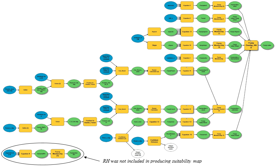
Fig. A1. GIS tool and Fuzzy model for the determination of suitable locations for solar kilns (without the RH layer)